National Parks in Wales are areas of outstanding natural beauty that are protected and managed to preserve their special qualities for the enjoyment of future generations. They provide a place of tranquillity and recreation for visitors to enjoy. There are three national parks within Wales, all of which are managed by local authorities.
Introduction to National Parks in Wales
National parks in Wales were established by the National Parks (Wales) Act of 1951. Brecon Beacons was created on 30 April 1957, Pembrokeshire Coast on 23 August 1956 and Snowdonia on 1 April 1954. These parks cover an area of 586 square miles (1553 km²), 1,419 square miles (3700km²) and 787 square miles (2113km²) respectively.
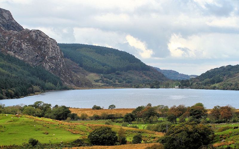
Snowdonia National Park
The area of Snowdonia National Park was designated as a national park because there are many geological features and habitats that make it very unique. The landscape is affected by uplift of the land, glaciation and many other factors. The area has a variety of habitats including lakes, steep sided valleys, marshy mires and oak woodlands. It is one of the best areas in Britain for breeding lesser black-backed gulls.
Dyffryn Nantlle is a small area of Snowdonia National Park located in Gwynedd, north west Wales. It is situated at the edge of the Snowdon massif, just south of the Nantlle Valley. There are many unique features in this small area, including Pen Llithrig y Wrach (the highest waterfall in Wales at 120 ft or 37 m), a lake formed by the damming of Afon Cwm Silyn and Cwm Silyn which is a steep sided valley that cuts through the Snowdon massif. There are also two lakes, Nantlle and Llyn Y Cwn which have clear water that is rich in wildlife and a wide variety of aquatic plants.
Visiting Snowdonia National Park
You can get to Snowdonia National Park by car (Beddgelert has a car park), mainline railway station with regular trains to Porthmadog, Bangor and Caernarfon (via Penrhyndeudraeth). There are also regular buses to Porthmadog, Caernarfon and Bangor.
Camping and accommodation
there are many campsites near Snowdon at Llanberis (Nant Gwrtheyrn), Dolgarrog, Pen-y-pass and Beddgelert which have caravans, camping and both static and touring pitches. There are also several holiday parks with chalets and lodges. There is a youth hostel at Pen-y-Pass, two campsites associated with hostels in Dolgellau and Nantgwynant and several farm accommodation sites.
There are several National Park Information Centres – for tourist information and walking guides just drop in and they will help you. Find out more on the Tourism Snowdonia info site.
Pen-y-Pas
From Pen-y-Pas car park you can walk to the top of Snowdon, along one of several paths including Heol Senni, Rhyd Ddu path or the Pyg track. The Pen-y-Pas centre has toilets and a cafe. It is also a well known spot for climbers.
Beddgelert
This pretty village lies within Snowdonia National Park on the River Glaslyn which runs into Bala lake. The village has a variety of facilities including shops, cafes, pubs, hotels and a campsite. There are regular buses from Beddgelert to Porthmadog (8 miles), Caernarfon (15 miles) and Bangor (20 miles). There are many waymarked paths around Beddgelert which take you through beautiful scenery.
Porthmadog
Porthmadog is one of the best areas of Snowdonia national park to go walking due to the beautiful scenery, plenty of outdoor activities, National Park Centre and excellent transport links
Snowdon Ranger Path and Crib Goch Trail
The ranger path takes you through Gwynant pass, along Bwlch Glas and past Llyn Idwal, one of many lakes within Snowdonia. The Crib Goch trail is the route taken by miners to get from Nantlle valley to Llanberis.
Brecon Beacons National Park
The Brecon Beacons are thought to be the remnants of a larger land mass that once connected Wales and Ireland. The national park is home to many rare and endangered species, including invertebrates such as ladybirds and ground beetles. There are many lakes within the park, including Llyn Brianne (the largest natural body of water in South Wales), Craig Goch reservoir and Mwyngloddfa Gwynion, a scenic lake formed in the shape of a figure of eight.
The Brecon Beacons National Park has very varied geology due to its location at the edge of two former ice sheets. It is also an area where you can find many different habitats such as oak woodland, heathland and grasslands.
Brecon Beacons is the most mountainous areas of Wales with areas such as Fforest Fawr and Black Mountain being very high at over 350 meters. There are many attractions within Brecon Beacons National Park including Pen y Fan mountain which has an elevation of 886 meters making it the highest point in South Wales.
Visiting Brecon Beacons
Brecon Beacons National Park has many attractions for visitors, including the Brecon Mountain Railway which was opened in 1832 making it one of the oldest mountain railways in Britain. There is a visitor centre called Afon Gwydderig near Llyn Brianne which opened in 2009.
Brecon Jazz Festival
Brecon Beacons National Park is home to the Brecon Jazz Festival which takes place over five days each July and has been running since 1995, making it one of the longest running jazz festivals in Britain. Every year many bands play at this festival including big names such as Van Morrison, Jools Holland and Roy Ayers.
Llyn Brianne
Llyn Brianne was the first reservoir in Wales to be created for the generation of electricity through hydro-electric power. It was opened on 24 October 1911 and contains around 22 million cubic metres of water, enough to fill 880 Olympic swimming pools. The lake is one of the main tourist attractions in Brecon Beacons National Park.
Fforest Fawr
Fforest Fawr covers the majority of Brecon Beacons National Park and is home to a large number of rare and endangered species. It is an area that has many mountains, valleys, rivers and lakes as well as oak woodland, heathland and grasslands making it one of the most varied areas in Wales. There are around 80 different species of butterfly and 300 types of moths in the park.
Pembrokeshire Coast
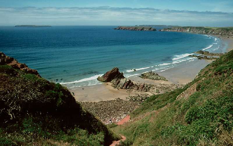
The Pembrokeshire Coast is an Area of Outstanding Natural Beauty, stretching for some 60 miles. It is characterised by high cliffs, pretty sandy beaches and many islands. St Govan’s Island has a lighthouse built using 3rd millennium BC stones.
Thousands of people visit the national parks for their tourism and leisure opportunities, making a significant contribution to the economy of coastal rural areas and creating employment in both urban and rural communities.
These parklands are important habitats for many rare plants and animals, from marine mammals, birds such as pink-footed geese, choughs, razorbills, puffins and Manx shearwaters to aquatic plants in the rivers and estuaries. We have a network of paths that let you explore both parks.
The coastal landscape is varied: mountains, cliff tops and high moorland alternate with sandy beaches, tranquil harbours, river valleys and fertile fields. The combined area of Cardigan Bay and Carmarthen Bay is about 6,000 hectares (15,000 acres) – an ideal size for a park. A Park Authority will be set up to help protect these areas and improve the quality of life for those who live or work in the area.
The national parks are important as wildlife corridors that provide vital connections for many species of plants and animals. Many species can move across the Parks along coastal routes, between rivers and habitats such as sand dunes and salt marshes.
The importance of Pembrokeshire’s coast for wildlife was recognised in 2005 when it was listed as a World Heritage Site, jointly with the nearby Gower Peninsula. The Pembrokeshire Coast is also a Special Protection Area for wildlife, where all kinds of sea birds nest and rear their young.
It is an important habitat for the endangered European Otter which was re-introduced here in 2001 as part of a carefully managed programme. Other animals such as Sea Urchins and Shingle Worms are also found living along the Pembrokeshire Coast.
The coastal landscapes of the Pembrokeshire Coast have changed since the last Ice Age (10-15,000 years ago), when Wales was covered by ice sheets and glaciers with deep valleys where today we have a gently sloping coastline. This is an area with a fascinating geology, with rock formations including the famous Priory and Castle Ditches.
Visiting Pembrokeshire Coast
The National Park coastline includes Cardigan Bay and Carmarthen Bay, the Pembrokeshire Coast Path and the Pembrokeshire Coast (an Area of Outstanding Natural Beauty). There are some fantastic coastal walks in both parks.
The area has been inhabited for over 6,000 years; there are many remains of ancient settlements such as hillforts at Sygun and Castell Henllys, nearby Bronze Age burial cairns and Neolithic standing stones like the Swallow Stone and St Govan’s Head.
In the medieval period, the castles at Carew and Tenby were frequently attacked from the sea.
If you enjoyed this blog you might also like to read about the National Parks in England and the National Parks in Scotland.
1 thought on “Visiting the National Parks in Wales”